


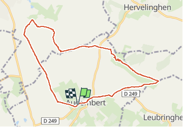
Sentier de La Hocque Audembert

tenace
User

Length
9.2 km

Max alt
161 m

Uphill gradient
153 m
Km-Effort
11.2 km

Min alt
25 m

Downhill gradient
155 m
Boucle
Yes
Creation date :
2022-05-18 13:26:37.788
Updated on :
2022-05-18 16:08:59.564
2h41
Difficulty : Medium

FREE GPS app for hiking
 SityTrail
IGN / Geographical institutes
SityTrail Plus
The world is yours!
About
Trail Walking of 9.2 km to be discovered at Hauts-de-France, Pas-de-Calais, Audembert. This trail is proposed by tenace.
Description
Randonnée
Positioning
Country:
France
Region :
Hauts-de-France
Department/Province :
Pas-de-Calais
Municipality :
Audembert
Location:
Unknown
Start:(Dec)
Start:(UTM)
407855 ; 5635184 (31U) N.
Comments