


montge 5.9 km ++

nini77230
User
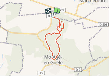

Length
6.2 km

Max alt
209 m

Uphill gradient
114 m
Km-Effort
7.8 km

Min alt
130 m

Downhill gradient
114 m
Boucle
Yes
Creation date :
2022-05-19 07:21:25.096
Updated on :
2022-05-19 09:32:26.89
2h10
Difficulty : Medium

FREE GPS app for hiking
 SityTrail
IGN / Geographical institutes
SityTrail Plus
The world is yours!
About
Trail Walking of 6.2 km to be discovered at Ile-de-France, Seine-et-Marne, Montgé-en-Goële. This trail is proposed by nini77230.
Positioning
Country:
France
Region :
Ile-de-France
Department/Province :
Seine-et-Marne
Municipality :
Montgé-en-Goële
Location:
Unknown
Start:(Dec)
Start:(UTM)
481590 ; 5432384 (31U) N.
Comments