


toussiere

Liebeaux
User

Length
9.9 km

Max alt
1895 m

Uphill gradient
910 m
Km-Effort
22 km

Min alt
997 m

Downhill gradient
910 m
Boucle
Yes
Creation date :
2022-05-19 07:09:56.239
Updated on :
2022-05-19 13:21:11.782
6h10
Difficulty : Very difficult

FREE GPS app for hiking
 SityTrail
IGN / Geographical institutes
SityTrail Plus
The world is yours!
About
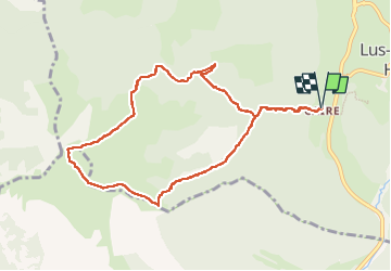
Trail Walking of 9.9 km to be discovered at Auvergne-Rhône-Alpes, Drôme, Lus-la-Croix-Haute. This trail is proposed by Liebeaux.
Positioning
Country:
France
Region :
Auvergne-Rhône-Alpes
Department/Province :
Drôme
Municipality :
Lus-la-Croix-Haute
Location:
Unknown
Start:(Dec)
Start:(UTM)
713483 ; 4948724 (31T) N.
Comments