


Vercors 4ème étape Archiane 19 mai 2022

rlebasque
User
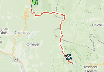

Length
22 km

Max alt
1673 m

Uphill gradient
820 m
Km-Effort
34 km

Min alt
768 m

Downhill gradient
1310 m
Boucle
No
Creation date :
2022-05-19 05:52:57.1
Updated on :
2022-05-19 15:24:53.612
9h31
Difficulty : Very difficult

FREE GPS app for hiking
 SityTrail
IGN / Geographical institutes
SityTrail Plus
The world is yours!
About
Trail Walking of 22 km to be discovered at Auvergne-Rhône-Alpes, Drôme, Saint-Agnan-en-Vercors. This trail is proposed by rlebasque.
Positioning
Country:
France
Region :
Auvergne-Rhône-Alpes
Department/Province :
Drôme
Municipality :
Saint-Agnan-en-Vercors
Location:
Unknown
Start:(Dec)
Start:(UTM)
690134 ; 4967939 (31T) N.
Comments