Trail Walking Saint-Martial - mont Gerbier ajouter 3km  - Photo
 taguette
taguette

User

© OpenStreetMap contributors
Length
Length
12.4 km
Max alt
Max alt
1526 m
Uphill gradient
Uphill gradient
586 m
Km-Effort
Km-Effort  
20 km
Min alt
Min alt
961 m
Downhill gradient
Downhill gradient
521 m
Boucle
Boucle
No
Creation date :
2022-05-20 06:10:01.938
Updated on :
2022-05-20 09:46:13.333

(0 Reviews)

Walking
Walking
4h10
Difficulty : Very difficult

Scan this QR Code to open this trail in the SityTrail application

FREE GPS app for hiking

Logo SityTrail SityTrail

IGN / Geographical institutes

Download SityTrail from the App Store Download SityTrail from Google Play

Logo SityTrail SityTrail World

The world is yours!

Download SityTrail from the App Store Download SityTrail from Google Play Download SityTrail on Huawei AppGallery

About

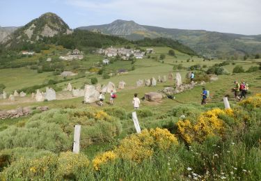
Trail Walking of 12.4 km to be discovered at Auvergne-Rhône-Alpes, Ardèche, Saint-Martial. This trail is proposed by taguette.

Description

manque 3 km compteur pas déclanché fin très technique.

Elevation profile

Positioning

Country:
France
Region :
Auvergne-Rhône-Alpes
Department/Province :
Ardèche
Municipality :
Saint-Martial
Location:
Unknown
Start:(UTM)
594935 ; 4968034 (31T) N.

Trails nearby

Trail Mountain bike Les Estables - Site VTT FFC du Mézenc et de la Loire sauvage - Circuit n° 04 - Tour du Mont Alambre  - Photo
Mountain bike
tracegps

Mountain bike

Medium
(1)
Les Estables, Auvergne-Rhône-Alpes, Haute-Loire, France
8.6 km | 11.9 km-effort
1h 0min
Yes
Trail Mountain bike Les Estables - Site VTT FFC du Mézenc et de la Loire sauvage - Circuit n° 07 - Boucle en foret domaniale  - Photo
Mountain bike
tracegps

Mountain bike

Difficult
(1)
Les Estables, Auvergne-Rhône-Alpes, Haute-Loire, France
19.9 km | 26 km-effort
2h 0min
Yes
Trail Walking Borée - Boree Mezenc Croix Boutieres 19km - Photo
Walking
GUIDE
thonyc

Walking

Difficult
Borée, Auvergne-Rhône-Alpes, Ardèche, France
26 km | 38 km-effort
8h 40min
Yes
Trail Walking Cros-de-Géorand - 2023-01-26_11h39m18_Le Béage-Tour des Sucs 15km.gpx.xml - Photo
Walking
chancha

Walking

Difficult
Cros-de-Géorand, Auvergne-Rhône-Alpes, Ardèche, France
15.2 km | 23 km-effort
5h 8min
Yes
Trail Walking Le Béage - suc du montfol et lauzière - Photo
Walking
nadd73

Walking

Easy
Le Béage, Auvergne-Rhône-Alpes, Ardèche, France
10.9 km | 16 km-effort
2h 32min
Yes
Trail Walking Borée - Tour du Mont Mézenc 14,5km - Photo
Walking
GUIDE
thonyc

Walking

Medium
Borée, Auvergne-Rhône-Alpes, Ardèche, France
14.5 km | 21 km-effort
4h 47min
Yes
Trail Walking Saint-Martial - Sucs de Montfol et de La Lauziere 11km - Photo
Walking
GUIDE
thonyc

Walking

Medium
Saint-Martial, Auvergne-Rhône-Alpes, Ardèche, France
10.6 km | 15.4 km-effort
4h 34min
Yes
Trail Walking Borée - bonnefoy les sucs - Photo
Walking
07es18

Walking

Medium
(1)
Borée, Auvergne-Rhône-Alpes, Ardèche, France
13.4 km | 0 m-effort
4h 20min
Yes
Trail Walking Borée - Randonnée au Mont Mézenc  - Photo
Walking
choubaka77

Walking

Medium
Borée, Auvergne-Rhône-Alpes, Ardèche, France
6.3 km | 9.6 km-effort
3h 33min
Yes


Close
My subscriptions