


Saint Étienne

MAUVAGE Patrick
User
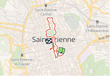

Length
3.2 km

Max alt
532 m

Uphill gradient
35 m
Km-Effort
3.6 km

Min alt
514 m

Downhill gradient
31 m
Boucle
No
Creation date :
2022-05-21 14:03:01.0
Updated on :
2022-05-21 15:11:16.27
50m
Difficulty : Easy

FREE GPS app for hiking
 SityTrail
IGN / Geographical institutes
SityTrail Plus
The world is yours!
About
Trail Walking of 3.2 km to be discovered at Auvergne-Rhône-Alpes, Loire, Saint-Étienne. This trail is proposed by MAUVAGE Patrick.
Photos


Positioning
Country:
France
Region :
Auvergne-Rhône-Alpes
Department/Province :
Loire
Municipality :
Saint-Étienne
Location:
Unknown
Start:(Dec)
Start:(UTM)
608600 ; 5032392 (31T) N.
Comments