


j3

apa
User

Length
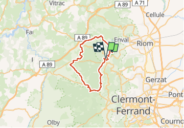
42 km

Max alt
1055 m

Uphill gradient
753 m
Km-Effort
52 km

Min alt
596 m

Downhill gradient
752 m
Boucle
Yes
Creation date :
2022-05-22 06:36:54.934
Updated on :
2022-05-22 11:54:52.092
4h34
Difficulty : Very difficult

FREE GPS app for hiking
 SityTrail
IGN / Geographical institutes
SityTrail Plus
The world is yours!
About
Trail Mountain bike of 42 km to be discovered at Auvergne-Rhône-Alpes, Puy-de-Dôme, Volvic. This trail is proposed by apa.
Photos

Positioning
Country:
France
Region :
Auvergne-Rhône-Alpes
Department/Province :
Puy-de-Dôme
Municipality :
Volvic
Location:
Unknown
Start:(Dec)
Start:(UTM)
500697 ; 5078904 (31T) N.
Comments