


home/ pierre tombante

Tof Tof
User
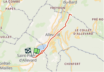

Length
12.6 km

Max alt
711 m

Uphill gradient
587 m
Km-Effort
20 km

Min alt
471 m

Downhill gradient
586 m
Boucle
Yes
Creation date :
2022-05-22 12:25:18.676
Updated on :
2022-05-22 16:07:25.324
3h41
Difficulty : Medium

FREE GPS app for hiking
 SityTrail
IGN / Geographical institutes
SityTrail Plus
The world is yours!
About
Trail Walking of 12.6 km to be discovered at Auvergne-Rhône-Alpes, Isère, Crêts-en-Belledonne. This trail is proposed by Tof Tof.
Positioning
Country:
France
Region :
Auvergne-Rhône-Alpes
Department/Province :
Isère
Municipality :
Crêts-en-Belledonne
Location:
Unknown
Start:(Dec)
Start:(UTM)
269092 ; 5028776 (32T) N.
Comments