


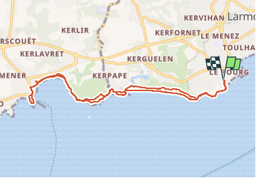
Larmor plage - Lomener A/R

adubarry
User

Length
10 km

Max alt
9 m

Uphill gradient
62 m
Km-Effort
10.8 km

Min alt
-2 m

Downhill gradient
62 m
Boucle
Yes
Creation date :
2022-05-23 11:11:44.92
Updated on :
2022-05-23 14:00:43.642
2h42
Difficulty : Medium

FREE GPS app for hiking
 SityTrail
IGN / Geographical institutes
SityTrail Plus
The world is yours!
About
Trail Walking of 10 km to be discovered at Brittany, Morbihan, Larmor-Plage. This trail is proposed by adubarry.
Positioning
Country:
France
Region :
Brittany
Department/Province :
Morbihan
Municipality :
Larmor-Plage
Location:
Unknown
Start:(Dec)
Start:(UTM)
471099 ; 5283530 (30T) N.
Comments