FORET DU CRANOU

aderas
User
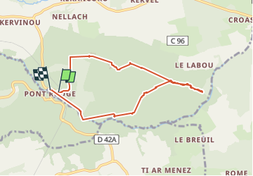

Length
7.2 km

Max alt
225 m

Uphill gradient
149 m
Km-Effort
9.2 km

Min alt
98 m

Downhill gradient
156 m
Boucle
Yes
Creation date :
2022-05-21 13:25:32.057
Updated on :
2022-05-23 15:31:48.858
1h57
Difficulty : Easy

FREE GPS app for hiking
 SityTrail
IGN / Geographical institutes
SityTrail Plus
The world is yours!
About
Trail Walking of 7.2 km to be discovered at Brittany, Finistère, Hanvec. This trail is proposed by aderas.
Description
ballade en forêt
Positioning
Country:
France
Region :
Brittany
Department/Province :
Finistère
Municipality :
Hanvec
Location:
Unknown
Start:(Dec)
Start:(UTM)
418500 ; 5351928 (30U) N.
Comments