


GR 10 22

chasle
User
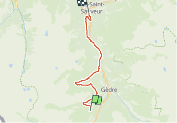

Length
21 km

Max alt
1866 m

Uphill gradient
689 m
Km-Effort
33 km

Min alt
739 m

Downhill gradient
1557 m
Boucle
No
Creation date :
2022-05-23 22:43:20.294
Updated on :
2022-05-23 22:43:58.33
7h32
Difficulty : Difficult

FREE GPS app for hiking
 SityTrail
IGN / Geographical institutes
SityTrail Plus
The world is yours!
About
Trail Walking of 21 km to be discovered at Occitania, Hautespyrenees, Gavarnie-Gèdre. This trail is proposed by chasle.
Positioning
Country:
France
Region :
Occitania
Department/Province :
Hautespyrenees
Municipality :
Gavarnie-Gèdre
Location:
Gèdre
Start:(Dec)
Start:(UTM)
744940 ; 4739178 (30T) N.
Comments