Trail Walking Ollioules - Château Vallon -25-05-22 - Photo

Château Vallon -25-05-22

© OpenStreetMap contributors
Length
Length
14.2 km
Max alt
Max alt
506 m
Uphill gradient
Uphill gradient
637 m
Km-Effort
Km-Effort  
23 km
Min alt
Min alt
114 m
Downhill gradient
Downhill gradient
639 m
Boucle
Boucle
Yes
Creation date :
2022-05-25 06:36:55.304
Updated on :
2022-05-25 15:31:11.406

(0 Reviews)

Walking
Walking
4h11
Difficulty : Medium

Scan this QR Code to open this trail in the SityTrail application

FREE GPS app for hiking

Logo SityTrail SityTrail

IGN / Geographical institutes

Download SityTrail from the App Store Download SityTrail from Google Play

Logo SityTrail SityTrail Plus

The world is yours!

Download SityTrail from the App Store Download SityTrail from Google Play Download SityTrail on Huawei AppGallery

About

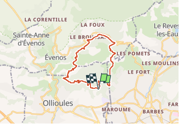
Trail Walking of 14.2 km to be discovered at Provence-Alpes-Côte d'Azur, Var, Ollioules. This trail is proposed by Christiancordin.

Description

Château Vallon-four à chaux du Détras-appié du Détras-col du télégraphe-télégraphe de Chappe-four à cade-les Hts du Destel-vallon du corps de garde-col du corps de garde-GR 51-vallon de la grille-vallon des bonnes herbes.

Elevation profile

Photos

Positioning

Country:
France
Region :
Provence-Alpes-Côte d'Azur
Department/Province :
Var
Municipality :
Ollioules
Location:
Unknown
Start:(UTM)
733923 ; 4781124 (31T) N.


Close
My subscriptions