


Le tour du Chaussitre

psesjs
User
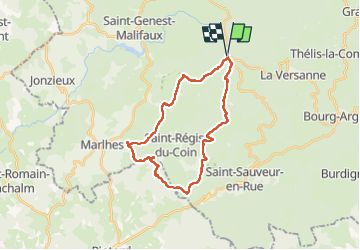

Length
26 km

Max alt
1303 m

Uphill gradient
719 m
Km-Effort
35 km

Min alt
971 m

Downhill gradient
719 m
Boucle
Yes
Creation date :
2022-05-25 06:29:03.245
Updated on :
2022-05-25 14:45:39.899
6h12
Difficulty : Medium

FREE GPS app for hiking
 SityTrail
IGN / Geographical institutes
SityTrail Plus
The world is yours!
About
Trail Walking of 26 km to be discovered at Auvergne-Rhône-Alpes, Loire, Saint-Genest-Malifaux. This trail is proposed by psesjs.
Positioning
Country:
France
Region :
Auvergne-Rhône-Alpes
Department/Province :
Loire
Municipality :
Saint-Genest-Malifaux
Location:
Unknown
Start:(Dec)
Start:(UTM)
616069 ; 5020275 (31T) N.
Comments