


miery

ymobernard
User
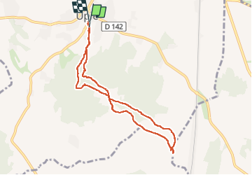

Length
8 km

Max alt
389 m

Uphill gradient
255 m
Km-Effort
11.5 km

Min alt
225 m

Downhill gradient
270 m
Boucle
Yes
Creation date :
2022-05-25 11:56:02.734
Updated on :
2022-05-25 14:57:56.649
2h22
Difficulty : Easy

FREE GPS app for hiking
 SityTrail
IGN / Geographical institutes
SityTrail Plus
The world is yours!
About
Trail Walking of 8 km to be discovered at Auvergne-Rhône-Alpes, Drôme, Upie. This trail is proposed by ymobernard.
Positioning
Country:
France
Region :
Auvergne-Rhône-Alpes
Department/Province :
Drôme
Municipality :
Upie
Location:
Unknown
Start:(Dec)
Start:(UTM)
656595 ; 4962900 (31T) N.
Comments