


metabief jougne

robert gallet
User
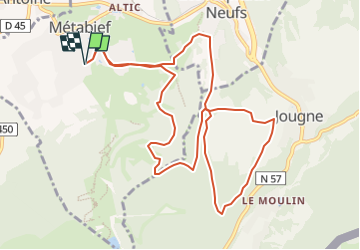

Length
11.7 km

Max alt
1165 m

Uphill gradient
320 m
Km-Effort
16 km

Min alt
996 m

Downhill gradient
320 m
Boucle
Yes
Creation date :
2022-05-25 19:39:20.098
Updated on :
2022-05-25 19:40:08.2
3h37
Difficulty : Easy

FREE GPS app for hiking
 SityTrail
IGN / Geographical institutes
SityTrail Plus
The world is yours!
About
Trail On foot of 11.7 km to be discovered at Bourgogne-Franche-Comté, Doubs, Métabief. This trail is proposed by robert gallet.
Positioning
Country:
France
Region :
Bourgogne-Franche-Comté
Department/Province :
Doubs
Municipality :
Métabief
Location:
Unknown
Start:(Dec)
Start:(UTM)
297802 ; 5182900 (32T) N.
Comments