


Vattetot-Les Loges GR

JMCMoreau
User
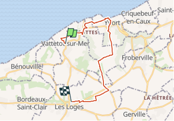

Length
10.6 km

Max alt
114 m

Uphill gradient
193 m
Km-Effort
13.2 km

Min alt
4 m

Downhill gradient
177 m
Boucle
No
Creation date :
2022-05-26 06:56:27.785
Updated on :
2022-05-26 07:04:23.795
6h30
Difficulty : Medium

FREE GPS app for hiking
 SityTrail
IGN / Geographical institutes
SityTrail Plus
The world is yours!
About
Trail Walking of 10.6 km to be discovered at Normandy, Seine-Maritime, Vattetot-sur-Mer. This trail is proposed by JMCMoreau.
Positioning
Country:
France
Region :
Normandy
Department/Province :
Seine-Maritime
Municipality :
Vattetot-sur-Mer
Location:
Unknown
Start:(Dec)
Start:(UTM)
304007 ; 5511955 (31U) N.
Comments