


bouverie bruno

ninia
User
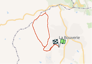

Length
7.3 km

Max alt
112 m

Uphill gradient
118 m
Km-Effort
8.8 km

Min alt
32 m

Downhill gradient
119 m
Boucle
Yes
Creation date :
2022-05-26 06:02:31.691
Updated on :
2022-05-26 08:25:44.689
2h22
Difficulty : Easy

FREE GPS app for hiking
 SityTrail
IGN / Geographical institutes
SityTrail Plus
The world is yours!
About
Trail Walking of 7.3 km to be discovered at Provence-Alpes-Côte d'Azur, Var, Roquebrune-sur-Argens. This trail is proposed by ninia.
Positioning
Country:
France
Region :
Provence-Alpes-Côte d'Azur
Department/Province :
Var
Municipality :
Roquebrune-sur-Argens
Location:
Unknown
Start:(Dec)
Start:(UTM)
309000 ; 4818619 (32T) N.
Comments