


trou chapelle live

Louna
User
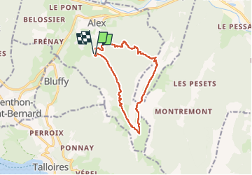

Length
12.4 km

Max alt
1838 m

Uphill gradient
1283 m
Km-Effort
30 km

Min alt
693 m

Downhill gradient
1299 m
Boucle
Yes
Creation date :
2022-05-26 07:24:20.341
Updated on :
2022-05-26 12:28:11.864
3h48
Difficulty : Very difficult

FREE GPS app for hiking
 SityTrail
IGN / Geographical institutes
SityTrail Plus
The world is yours!
About
Trail Walking of 12.4 km to be discovered at Auvergne-Rhône-Alpes, Upper Savoy, Alex. This trail is proposed by Louna .
Positioning
Country:
France
Region :
Auvergne-Rhône-Alpes
Department/Province :
Upper Savoy
Municipality :
Alex
Location:
Unknown
Start:(Dec)
Start:(UTM)
285581 ; 5084211 (32T) N.
Comments