


Pointe d’Orsière rando

Chabard
User
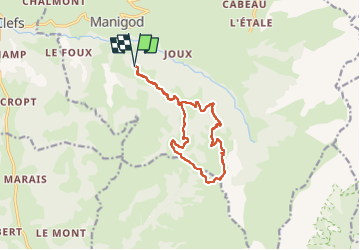

Length
13.2 km

Max alt
1748 m

Uphill gradient
676 m
Km-Effort
22 km

Min alt
1161 m

Downhill gradient
675 m
Boucle
Yes
Creation date :
2022-05-26 07:21:40.0
Updated on :
2022-05-26 13:13:10.845
5h50
Difficulty : Easy

FREE GPS app for hiking
 SityTrail
IGN / Geographical institutes
SityTrail Plus
The world is yours!
About
Trail Walking of 13.2 km to be discovered at Auvergne-Rhône-Alpes, Upper Savoy, Manigod. This trail is proposed by Chabard.
Description
Rando pointe d’Orsière
Positioning
Country:
France
Region :
Auvergne-Rhône-Alpes
Department/Province :
Upper Savoy
Municipality :
Manigod
Location:
Unknown
Start:(Dec)
Start:(UTM)
296255 ; 5080723 (32T) N.
Comments