


col bed

Bwattier
User
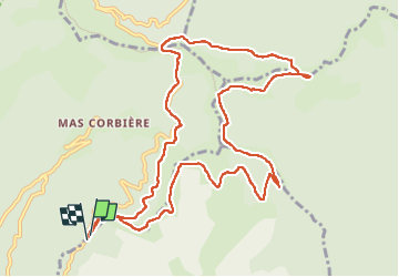

Length
13.2 km

Max alt
1147 m

Uphill gradient
586 m
Km-Effort
21 km

Min alt
709 m

Downhill gradient
595 m
Boucle
Yes
Creation date :
2022-05-26 07:44:29.977
Updated on :
2022-05-26 13:45:14.116
4h36
Difficulty : Very difficult

FREE GPS app for hiking
 SityTrail
IGN / Geographical institutes
SityTrail Plus
The world is yours!
About
Trail Walking of 13.2 km to be discovered at Occitania, Gard, Val-d'Aigoual. This trail is proposed by Bwattier.
Positioning
Country:
France
Region :
Occitania
Department/Province :
Gard
Municipality :
Val-d'Aigoual
Location:
Notre-Dame-de-la-Rouvière
Start:(Dec)
Start:(UTM)
558725 ; 4878445 (31T) N.
Comments