


etp11cde

tosan
User
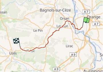

Length
41 km

Max alt
225 m

Uphill gradient
456 m
Km-Effort
47 km

Min alt
26 m

Downhill gradient
385 m
Boucle
No
Creation date :
2022-05-27 03:50:44.491
Updated on :
2022-05-27 18:32:27.429
12h50
Difficulty : Very difficult

FREE GPS app for hiking
 SityTrail
IGN / Geographical institutes
SityTrail Plus
The world is yours!
About
Trail Walking of 41 km to be discovered at Provence-Alpes-Côte d'Azur, Vaucluse, Caderousse. This trail is proposed by tosan.
Positioning
Country:
France
Region :
Provence-Alpes-Côte d'Azur
Department/Province :
Vaucluse
Municipality :
Caderousse
Location:
Unknown
Start:(Dec)
Start:(UTM)
640397 ; 4884823 (31T) N.
Comments