


chemin des mauras

bernardcornu
User
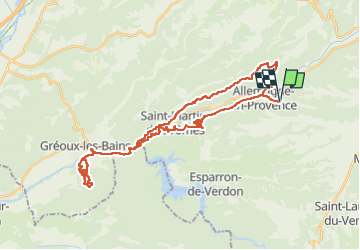

Length
41 km

Max alt
585 m

Uphill gradient
839 m
Km-Effort
52 km

Min alt
298 m

Downhill gradient
839 m
Boucle
Yes
Creation date :
2022-05-28 07:12:42.35
Updated on :
2022-05-28 10:41:41.933
2h39
Difficulty : Medium

FREE GPS app for hiking
 SityTrail
IGN / Geographical institutes
SityTrail Plus
The world is yours!
About
Trail Mountain bike of 41 km to be discovered at Provence-Alpes-Côte d'Azur, Alpes-de-Haute-Provence, Allemagne-en-Provence. This trail is proposed by bernardcornu.
Positioning
Country:
France
Region :
Provence-Alpes-Côte d'Azur
Department/Province :
Alpes-de-Haute-Provence
Municipality :
Allemagne-en-Provence
Location:
Unknown
Start:(Dec)
Start:(UTM)
260053 ; 4851738 (32T) N.
Comments