


Jura Mont d’Or

c.gourme
User
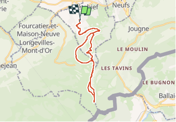

Length
16.4 km

Max alt
1450 m

Uphill gradient
617 m
Km-Effort
25 km

Min alt
1001 m

Downhill gradient
622 m
Boucle
Yes
Creation date :
2022-05-28 06:44:00.0
Updated on :
2022-05-28 14:15:27.174
6h02
Difficulty : Medium

FREE GPS app for hiking
 SityTrail
IGN / Geographical institutes
SityTrail Plus
The world is yours!
About
Trail Walking of 16.4 km to be discovered at Bourgogne-Franche-Comté, Doubs, Métabief. This trail is proposed by c.gourme.
Positioning
Country:
France
Region :
Bourgogne-Franche-Comté
Department/Province :
Doubs
Municipality :
Métabief
Location:
Unknown
Start:(Dec)
Start:(UTM)
297412 ; 5182634 (32T) N.
Comments