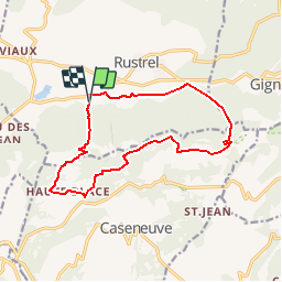
Rustrel
© OpenStreetMap contributors


4h12
Difficulty : Easy


Length
14.2 km
Max alt
572 m
Uphill gradient
413 m
Km-Effort
19.7 km
Min alt
313 m
Downhill gradient
407 m
Boucle
Yes
Creation date :
2014-12-10 00:00:00.0
Updated on :
2014-12-10 00:00:00.0
4h12
Difficulty : Easy
FREE GPS app for hiking
 SityTrail
IGN / Geographical institutes
SityTrail Plus
The world is yours!
About
Trail Walking of 14.2 km to be discovered at Provence-Alpes-Côte d'Azur, Vaucluse, Rustrel. This trail is proposed by maxime.ranchin@aliceadsl.fr.
Positioning
Country:
France
Region :
Provence-Alpes-Côte d'Azur
Department/Province :
Vaucluse
Municipality :
Rustrel
Location:
Unknown
Start:(Dec)
Start:(UTM)
698287 ; 4865396 (31T) N.
Comments