


fontaines en sologne

lecmic
User
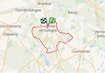

Length
27 km

Max alt
124 m

Uphill gradient
238 m
Km-Effort
30 km

Min alt
90 m

Downhill gradient
238 m
Boucle
Yes
Creation date :
2022-05-29 04:48:29.809
Updated on :
2022-05-29 09:26:35.994
3h58
Difficulty : Easy

FREE GPS app for hiking
 SityTrail
IGN / Geographical institutes
SityTrail Plus
The world is yours!
About
Trail Walking of 27 km to be discovered at Centre-Loire Valley, Loir-et-Cher, Fontaines-en-Sologne. This trail is proposed by lecmic.
Description
rando de la fraise
Positioning
Country:
France
Region :
Centre-Loire Valley
Department/Province :
Loir-et-Cher
Municipality :
Fontaines-en-Sologne
Location:
Unknown
Start:(Dec)
Start:(UTM)
390862 ; 5262968 (31T) N.
Comments