Trail Walking Valdeblore - Mont Pépoiri - Photo
© OpenStreetMap contributors
Length
Length
8.2 km
Max alt
Max alt
2657 m
Uphill gradient
Uphill gradient
673 m
Km-Effort
Km-Effort  
17.2 km
Min alt
Min alt
2031 m
Downhill gradient
Downhill gradient
678 m
Boucle
Boucle
Yes
Creation date :
2014-12-10 00:00:00.0
Updated on :
2014-12-10 00:00:00.0

(0 Reviews)

Walking
Walking
3h26
Difficulty : Difficult

Scan this QR Code to open this trail in the SityTrail application

FREE GPS app for hiking

Logo SityTrail SityTrail

IGN / Geographical institutes

Download SityTrail from the App Store Download SityTrail from Google Play

Logo SityTrail SityTrail Plus

The world is yours!

Download SityTrail from the App Store Download SityTrail from Google Play Download SityTrail on Huawei AppGallery

About

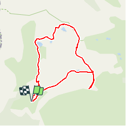
Trail Walking of 8.2 km to be discovered at Provence-Alpes-Côte d'Azur, Maritime Alps, Valdeblore. This trail is proposed by jmheydorff.

Description

Pkg à 2043 m, au-dessus de valdeblore.
Monter vers les lacs de Millefonds, par le Gr 52, que lon retrouvera après avoir longé les lacs .
Au col de Barn, monter en ligne de crête au Mt pépoiri.
Continuer la ligne de crête en SE; au col (2544m), descendre en hors piste jusqu'au pkg.
nota: on peut auparavant faire un AR au Mt Pétoumier

Elevation profile

Positioning

Country:
France
Region :
Provence-Alpes-Côte d'Azur
Department/Province :
Maritime Alps
Municipality :
Valdeblore
Location:
Unknown
Start:(UTM)
354845 ; 4884428 (32T) N.


Close
My subscriptions