


narrdyroux Puy sv

Bwattier
User
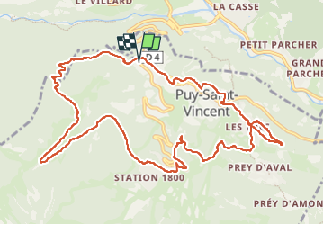

Length
14 km

Max alt
1800 m

Uphill gradient
617 m
Km-Effort
22 km

Min alt
1349 m

Downhill gradient
617 m
Boucle
Yes
Creation date :
2022-05-29 07:28:55.542
Updated on :
2022-05-29 13:01:02.065
4h54
Difficulty : Easy

FREE GPS app for hiking
 SityTrail
IGN / Geographical institutes
SityTrail Plus
The world is yours!
About
Trail Walking of 14 km to be discovered at Provence-Alpes-Côte d'Azur, Hautes-Alpes, Puy-Saint-Vincent. This trail is proposed by Bwattier.
Positioning
Country:
France
Region :
Provence-Alpes-Côte d'Azur
Department/Province :
Hautes-Alpes
Municipality :
Puy-Saint-Vincent
Location:
Unknown
Start:(Dec)
Start:(UTM)
300790 ; 4967520 (32T) N.
Comments