


Boucle - Biesme - Mettet - Ermeton - Maredret - Maredsous - Biesmeree -Stave - 45kms

jeanphi.hennebert
User
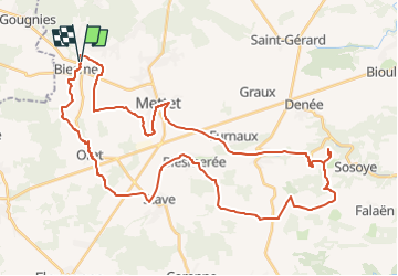

Length
44 km

Max alt
279 m

Uphill gradient
610 m
Km-Effort
52 km

Min alt
180 m

Downhill gradient
609 m
Boucle
Yes
Creation date :
2022-05-29 18:55:59.145
Updated on :
2022-05-29 18:55:59.145

FREE GPS app for hiking
 SityTrail
IGN / Geographical institutes
SityTrail Plus
The world is yours!
About
Trail of 44 km to be discovered at Wallonia, Namur, Mettet. This trail is proposed by jeanphi.hennebert.
Positioning
Country:
Belgium
Region :
Wallonia
Department/Province :
Namur
Municipality :
Mettet
Location:
Unknown
Start:(Dec)
Start:(UTM)
614600 ; 5577431 (31U) N.
Comments