


Route des vins d'Alsace modifiée

jeanphi.hennebert
User
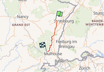

Length
138 km

Max alt
382 m

Uphill gradient
1510 m
Km-Effort
158 km

Min alt
166 m

Downhill gradient
1367 m
Boucle
No
Creation date :
2022-05-30 09:15:14.546
Updated on :
2022-05-30 09:15:14.546
--
Difficulty : Very difficult

FREE GPS app for hiking
 SityTrail
IGN / Geographical institutes
SityTrail Plus
The world is yours!
About
Trail Hybrid bike of 138 km to be discovered at Grand Est, Bas-Rhin, Westhoffen. This trail is proposed by jeanphi.hennebert.
Positioning
Country:
France
Region :
Grand Est
Department/Province :
Bas-Rhin
Municipality :
Westhoffen
Location:
Unknown
Start:(Dec)
Start:(UTM)
385227 ; 5384079 (32U) N.
Comments