


malpasset

ninia
User
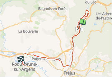

Length
31 km

Max alt
138 m

Uphill gradient
301 m
Km-Effort
35 km

Min alt
2 m

Downhill gradient
321 m
Boucle
No
Creation date :
2022-05-30 06:24:18.637
Updated on :
2022-05-30 10:38:37.177
3h28
Difficulty : Medium

FREE GPS app for hiking
 SityTrail
IGN / Geographical institutes
SityTrail Plus
The world is yours!
About
Trail Walking of 31 km to be discovered at Provence-Alpes-Côte d'Azur, Var, Fréjus. This trail is proposed by ninia.
Positioning
Country:
France
Region :
Provence-Alpes-Côte d'Azur
Department/Province :
Var
Municipality :
Fréjus
Location:
Unknown
Start:(Dec)
Start:(UTM)
318627 ; 4819278 (32T) N.
Comments