


Favieres Col de l’homme mort col de l’Asclier

psesjs
User
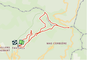

Length
11.3 km

Max alt
1010 m

Uphill gradient
492 m
Km-Effort
17.9 km

Min alt
641 m

Downhill gradient
494 m
Boucle
Yes
Creation date :
2022-05-31 07:59:55.0
Updated on :
2022-05-31 13:29:37.822
3h36
Difficulty : Easy

FREE GPS app for hiking
 SityTrail
IGN / Geographical institutes
SityTrail Plus
The world is yours!
About
Trail Walking of 11.3 km to be discovered at Occitania, Gard, Val-d'Aigoual. This trail is proposed by psesjs.
Positioning
Country:
France
Region :
Occitania
Department/Province :
Gard
Municipality :
Val-d'Aigoual
Location:
Notre-Dame-de-la-Rouvière
Start:(Dec)
Start:(UTM)
556712 ; 4879570 (31T) N.
Comments