Chalets de Clapeyto

lionelnottat
User
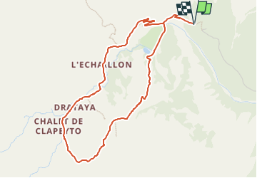

Length
5 km

Max alt
2280 m

Uphill gradient
325 m
Km-Effort
9.3 km

Min alt
1985 m

Downhill gradient
325 m
Boucle
Yes
Creation date :
2022-05-31 15:47:39.535
Updated on :
2022-05-31 15:48:21.395
2h07
Difficulty : Easy

FREE GPS app for hiking
 SityTrail
IGN / Geographical institutes
SityTrail Plus
The world is yours!
About
Trail Walking of 5 km to be discovered at Provence-Alpes-Côte d'Azur, Hautes-Alpes, Arvieux. This trail is proposed by lionelnottat.
Positioning
Country:
France
Region :
Provence-Alpes-Côte d'Azur
Department/Province :
Hautes-Alpes
Municipality :
Arvieux
Location:
Unknown
Start:(Dec)
Start:(UTM)
318574 ; 4963963 (32T) N.
Comments