


Juin022022GP

FPortier
User
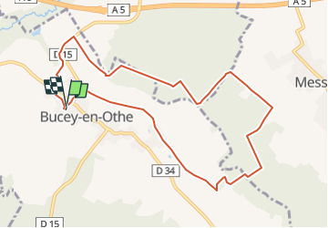

Length
9.8 km

Max alt
242 m

Uphill gradient
196 m
Km-Effort
12.4 km

Min alt
141 m

Downhill gradient
200 m
Boucle
Yes
Creation date :
2022-05-31 19:41:46.458
Updated on :
2022-05-31 19:42:28.724
2h48
Difficulty : Difficult

FREE GPS app for hiking
 SityTrail
IGN / Geographical institutes
SityTrail Plus
The world is yours!
About
Trail Walking of 9.8 km to be discovered at Grand Est, Aube, Bucey-en-Othe. This trail is proposed by FPortier.
Positioning
Country:
France
Region :
Grand Est
Department/Province :
Aube
Municipality :
Bucey-en-Othe
Location:
Unknown
Start:(Dec)
Start:(UTM)
563854 ; 5345558 (31U) N.
Comments