


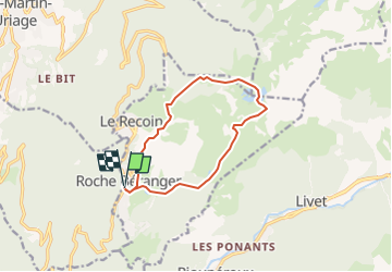
Lac Achard et Lacs Roberts

jphugon
User

Length
11.3 km

Max alt
2179 m

Uphill gradient
677 m
Km-Effort
20 km

Min alt
1726 m

Downhill gradient
681 m
Boucle
Yes
Creation date :
2022-06-01 06:34:43.556
Updated on :
2022-06-01 06:36:21.85
4h37
Difficulty : Very difficult

FREE GPS app for hiking
 SityTrail
IGN / Geographical institutes
SityTrail Plus
The world is yours!
About
Trail Walking of 11.3 km to be discovered at Auvergne-Rhône-Alpes, Isère, Chamrousse. This trail is proposed by jphugon.
Description
depart roche beranger
Positioning
Country:
France
Region :
Auvergne-Rhône-Alpes
Department/Province :
Isère
Municipality :
Chamrousse
Location:
Unknown
Start:(Dec)
Start:(UTM)
726153 ; 4999329 (31T) N.
Comments