


Distribution Roquettes

lebarça
User
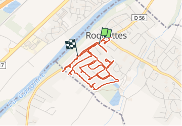

Length
7.2 km

Max alt
163 m

Uphill gradient
31 m
Km-Effort
7.7 km

Min alt
154 m

Downhill gradient
30 m
Boucle
No
Creation date :
2022-06-01 08:15:40.0
Updated on :
2022-06-01 10:42:10.074
2h26
Difficulty :

FREE GPS app for hiking
 SityTrail
IGN / Geographical institutes
SityTrail Plus
The world is yours!
About
Trail Walking of 7.2 km to be discovered at Occitania, Haute-Garonne, Roquettes. This trail is proposed by lebarça.
Positioning
Country:
France
Region :
Occitania
Department/Province :
Haute-Garonne
Municipality :
Roquettes
Location:
Unknown
Start:(Dec)
Start:(UTM)
367745 ; 4817462 (31T) N.
Comments