


Hohwald Zundelkof

ROPPJP
User
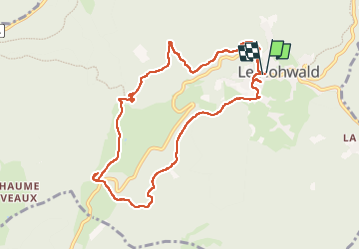

Length
9.6 km

Max alt
764 m

Uphill gradient
242 m
Km-Effort
12.8 km

Min alt
585 m

Downhill gradient
245 m
Boucle
Yes
Creation date :
2022-06-01 10:58:52.218
Updated on :
2022-06-04 09:03:01.383
3h02
Difficulty : Difficult

FREE GPS app for hiking
 SityTrail
IGN / Geographical institutes
SityTrail Plus
The world is yours!
About
Trail Walking of 9.6 km to be discovered at Grand Est, Bas-Rhin, Le Hohwald. This trail is proposed by ROPPJP.
Description
Départ du Hohwald. Passage au camping. Cascade de l'Andlau. Passage près de la Zundelhutte, lieu de naissance de mon père. Retour par le versant opposé. Sortie sympa, le plus souvent en forêt.
Photos

Positioning
Country:
France
Region :
Grand Est
Department/Province :
Bas-Rhin
Municipality :
Le Hohwald
Location:
Unknown
Start:(Dec)
Start:(UTM)
376003 ; 5362517 (32U) N.
Comments