


Domartemont

JeanPierreNancy
User
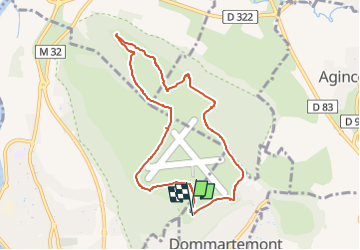

Length
7.8 km

Max alt
384 m

Uphill gradient
95 m
Km-Effort
9 km

Min alt
320 m

Downhill gradient
94 m
Boucle
Yes
Creation date :
2022-06-01 14:22:35.807
Updated on :
2022-06-01 14:22:38.282
2h03
Difficulty : Easy

FREE GPS app for hiking
 SityTrail
IGN / Geographical institutes
SityTrail Plus
The world is yours!
About
Trail Walking of 7.8 km to be discovered at Grand Est, Meurthe-et-Moselle, Dommartemont. This trail is proposed by JeanPierreNancy.
Positioning
Country:
France
Region :
Grand Est
Department/Province :
Meurthe-et-Moselle
Municipality :
Dommartemont
Location:
Unknown
Start:(Dec)
Start:(UTM)
294686 ; 5399748 (32U) N.
Comments