


Xon - Lesmenils

JeanPierreNancy
User
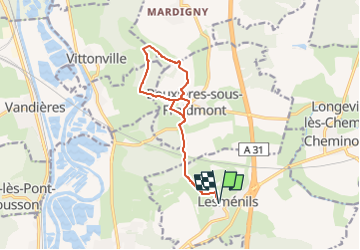

Length
11.7 km

Max alt
382 m

Uphill gradient
312 m
Km-Effort
15.9 km

Min alt
210 m

Downhill gradient
312 m
Boucle
Yes
Creation date :
2022-06-01 14:27:50.288
Updated on :
2022-06-01 14:27:53.439
3h36
Difficulty : Medium

FREE GPS app for hiking
 SityTrail
IGN / Geographical institutes
SityTrail Plus
The world is yours!
About
Trail Walking of 11.7 km to be discovered at Grand Est, Meurthe-et-Moselle, Lesménils. This trail is proposed by JeanPierreNancy.
Positioning
Country:
France
Region :
Grand Est
Department/Province :
Meurthe-et-Moselle
Municipality :
Lesménils
Location:
Unknown
Start:(Dec)
Start:(UTM)
287669 ; 5424033 (32U) N.
Comments