


Pen Det Pouri depuis Sers

Prala
User
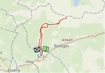

Length
14.7 km

Max alt
2542 m

Uphill gradient
1407 m
Km-Effort
33 km

Min alt
1138 m

Downhill gradient
1410 m
Boucle
Yes
Creation date :
2022-06-01 07:54:48.072
Updated on :
2022-06-01 17:55:06.887
4h49
Difficulty : Difficult

FREE GPS app for hiking
 SityTrail
IGN / Geographical institutes
SityTrail Plus
The world is yours!
About
Trail Walking of 14.7 km to be discovered at Occitania, Hautespyrenees, Sers. This trail is proposed by Prala.
Description
Crampons indispensables à l'approche du sommet
Positioning
Country:
France
Region :
Occitania
Department/Province :
Hautespyrenees
Municipality :
Sers
Location:
Unknown
Start:(Dec)
Start:(UTM)
258205 ; 4752602 (31T) N.
Comments