


fabas alain

ClubAgeHeureux
User
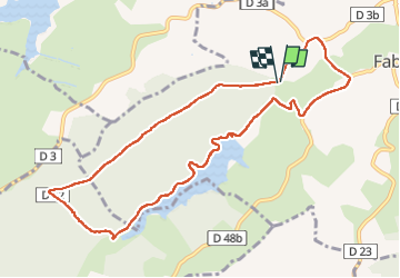

Length
10.9 km

Max alt
368 m

Uphill gradient
202 m
Km-Effort
13.5 km

Min alt
273 m

Downhill gradient
194 m
Boucle
Yes
Creation date :
2022-06-02 07:19:44.619
Updated on :
2022-06-02 10:12:21.881
2h30
Difficulty : Difficult

FREE GPS app for hiking
 SityTrail
IGN / Geographical institutes
SityTrail Plus
The world is yours!
About
Trail Walking of 10.9 km to be discovered at Occitania, Haute-Garonne, Fabas. This trail is proposed by ClubAgeHeureux.
Positioning
Country:
France
Region :
Occitania
Department/Province :
Haute-Garonne
Municipality :
Fabas
Location:
Unknown
Start:(Dec)
Start:(UTM)
327763 ; 4797637 (31T) N.
Comments