


Cb

niloc
User
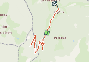

Length
9.4 km

Max alt
1529 m

Uphill gradient
391 m
Km-Effort
15 km

Min alt
1126 m

Downhill gradient
502 m
Boucle
No
Creation date :
2022-06-02 08:54:06.309
Updated on :
2022-06-02 16:31:51.313
3h12
Difficulty : Medium

FREE GPS app for hiking
 SityTrail
IGN / Geographical institutes
SityTrail Plus
The world is yours!
About
Trail Walking of 9.4 km to be discovered at Auvergne-Rhône-Alpes, Upper Savoy, Bellevaux. This trail is proposed by niloc.
Description
Cha van
Positioning
Country:
France
Region :
Auvergne-Rhône-Alpes
Department/Province :
Upper Savoy
Municipality :
Bellevaux
Location:
Unknown
Start:(Dec)
Start:(UTM)
312233 ; 5118559 (32T) N.
Comments