


comus

darobes
User
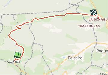

Length
14.6 km

Max alt
1368 m

Uphill gradient
290 m
Km-Effort
19.5 km

Min alt
877 m

Downhill gradient
609 m
Boucle
No
Creation date :
2022-06-04 06:28:35.934
Updated on :
2022-06-04 11:48:55.589
5h18
Difficulty : Very easy

FREE GPS app for hiking
 SityTrail
IGN / Geographical institutes
SityTrail Plus
The world is yours!
About
Trail Walking of 14.6 km to be discovered at Occitania, Aude, Comus. This trail is proposed by darobes.
Positioning
Country:
France
Region :
Occitania
Department/Province :
Aude
Municipality :
Comus
Location:
Unknown
Start:(Dec)
Start:(UTM)
409250 ; 4740675 (31T) N.
Comments