Trail Walking Cajarc - Etape14 Cajarc a Limogne en Quercy - Photo

Etape14 Cajarc a Limogne en Quercy

 lesduj
lesduj

User

© OpenStreetMap contributors
Length
Length
19.4 km
Max alt
Max alt
376 m
Uphill gradient
Uphill gradient
467 m
Km-Effort
Km-Effort  
25 km
Min alt
Min alt
142 m
Downhill gradient
Downhill gradient
320 m
Boucle
Boucle
No
Creation date :
2022-06-04 06:36:12.0
Updated on :
2022-06-04 19:39:05.942

(0 Reviews)

Walking
Walking
4h36
Difficulty : Easy

Scan this QR Code to open this trail in the SityTrail application

FREE GPS app for hiking

Logo SityTrail SityTrail

IGN / Geographical institutes

Download SityTrail from the App Store Download SityTrail from Google Play

Logo SityTrail SityTrail World

The world is yours!

Download SityTrail from the App Store Download SityTrail from Google Play Download SityTrail on Huawei AppGallery

About

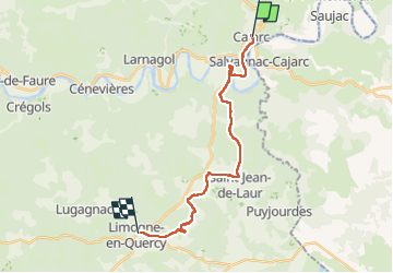
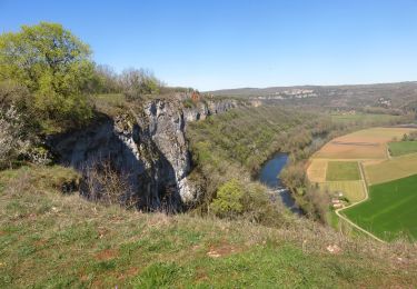
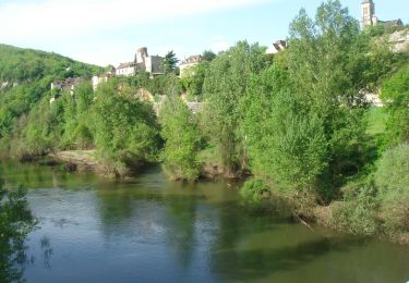
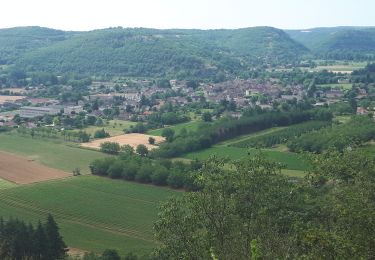
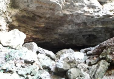
Trail Walking of 19.4 km to be discovered at Occitania, Lot, Cajarc. This trail is proposed by lesduj.

Description

Étape de 19 kms avec des parties bitumées,mais cette randonnée reste agréable par ses paysages diversifiés.
A découvrir

Elevation profile

Photos

Positioning

Country:
France
Region :
Occitania
Department/Province :
Lot
Municipality :
Cajarc
Location:
Unknown
Start:(UTM)
407982 ; 4926568 (31T) N.

Trails nearby

Trail Walking Saujac - Saujac-Bastides et Gorges de l'Aveyron - Photo
Walking
houbart

Walking

Difficult
(1)
Saujac, Occitania, Aveyron, France
9.7 km | 13 km-effort
2h 56min
Yes
Trail Walking Cajarc - Le Lot à Cajarc  - Photo
Walking
richardsimopons

Walking

Cajarc, Occitania, Lot, France
9.7 km | 11.8 km-effort
2h 16min
Yes
Trail Walking Cajarc - CC_Velay_DA_13_Cajarc_Bach_20080504 - Photo
Walking
patrickdanilo

Walking

Medium
Cajarc, Occitania, Lot, France
32 km | 40 km-effort
7h 20min
No
Trail Walking Cajarc - Cajarc (Boucle) - Photo
Walking
neitag61

Walking

Difficult
Cajarc, Occitania, Lot, France
12.6 km | 17 km-effort
3h 39min
Yes
Trail Walking Calvignac - calvignac cenevieres - Photo
Walking
yves12

Walking

Medium
Calvignac, Occitania, Lot, France
19.4 km | 28 km-effort
5h 29min
Yes
Trail Walking Salvagnac-Cajarc - roc de lantouy2024 - Photo
Walking
grfr12

Walking

Difficult
Salvagnac-Cajarc, Occitania, Aveyron, France
10.5 km | 15.3 km-effort
2h 55min
Yes
Trail Walking Cajarc - Carjac Limogne Varaire - Photo
Walking
Nono55

Walking

Easy
Cajarc, Occitania, Lot, France
30 km | 39 km-effort
6h 29min
No
Trail Walking Saint-Chels - St chels - Photo
Walking
gcournac

Walking

Very difficult
Saint-Chels, Occitania, Lot, France
18.7 km | 25 km-effort
4h 40min
Yes
Trail Mountain bike Montbrun - VTT Montbrun 31km 900D+ 11 MARS 2020 001 - Photo
Mountain bike
Levillefranchois

Mountain bike

Medium
Montbrun, Occitania, Lot, France
30 km | 41 km-effort
2h 51min
Yes


Close
My subscriptions