


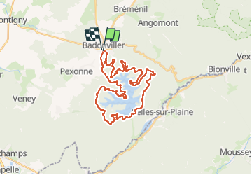
sortie vtt 05062022 rando des lacs

fabwin
User GUIDE

Length
34 km

Max alt
491 m

Uphill gradient
873 m
Km-Effort
46 km

Min alt
311 m

Downhill gradient
874 m
Boucle
Yes
Creation date :
2022-06-05 06:24:23.169
Updated on :
2022-06-05 10:07:27.219
2h57
Difficulty : Difficult

FREE GPS app for hiking
 SityTrail
IGN / Geographical institutes
SityTrail Plus
The world is yours!
About
Trail Mountain bike of 34 km to be discovered at Grand Est, Meurthe-et-Moselle, Badonviller. This trail is proposed by fabwin.
Positioning
Country:
France
Region :
Grand Est
Department/Province :
Meurthe-et-Moselle
Municipality :
Badonviller
Location:
Unknown
Start:(Dec)
Start:(UTM)
344306 ; 5373636 (32U) N.
Comments