


Ottenhoffen

pmauvieux
User
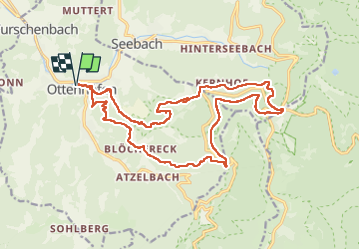

Length
20 km

Max alt
1001 m

Uphill gradient
866 m
Km-Effort
32 km

Min alt
298 m

Downhill gradient
866 m
Boucle
Yes
Creation date :
2022-06-05 08:02:08.792
Updated on :
2022-06-06 09:30:19.969
5h17
Difficulty : Difficult

FREE GPS app for hiking
 SityTrail
IGN / Geographical institutes
SityTrail Plus
The world is yours!
About
Trail Walking of 20 km to be discovered at Baden-Württemberg, Ortenaukreis, Ottenhöfen im Schwarzwald. This trail is proposed by pmauvieux.
Positioning
Country:
Germany
Region :
Baden-Württemberg
Department/Province :
Ortenaukreis
Municipality :
Ottenhöfen im Schwarzwald
Location:
Unknown
Start:(Dec)
Start:(UTM)
437329 ; 5379638 (32U) N.
Comments