


ETAPE 1 SMV ESTABLES PAR SIGNON

cbenoit38
User
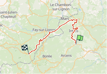

Length
46 km

Max alt
1571 m

Uphill gradient
1565 m
Km-Effort
65 km

Min alt
522 m

Downhill gradient
739 m
Boucle
No
Creation date :
2022-06-06 07:11:38.998
Updated on :
2022-06-06 07:11:54.458

FREE GPS app for hiking
 SityTrail
IGN / Geographical institutes
SityTrail Plus
The world is yours!
About
Trail of 46 km to be discovered at Auvergne-Rhône-Alpes, Ardèche, Saint-Martin-de-Valamas. This trail is proposed by cbenoit38.
Positioning
Country:
France
Region :
Auvergne-Rhône-Alpes
Department/Province :
Ardèche
Municipality :
Saint-Martin-de-Valamas
Location:
Unknown
Start:(Dec)
Start:(UTM)
608309 ; 4976814 (31T) N.
Comments