


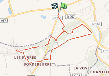
Circuit au lieu-dit Bordebeure Marcilly-en-Beauce

guydu41
User


1h30
Difficulty : Medium

FREE GPS app for hiking
 SityTrail
IGN / Geographical institutes
SityTrail Plus
The world is yours!
About
Trail Walking of 5.3 km to be discovered at Centre-Loire Valley, Loir-et-Cher, Naveil. This trail is proposed by guydu41.
Description
Ce petit circuit emprunte essentiellement des chemins souvent herbeux dans la campagne vendômoise, des sentiers étroits et tortueux dans des bois, passe plusieurs fois sous la petite ligne TER par des passages souterrains, offre un très beau point de vue sur la Vallée du Loir, permet la découverte du polissoir de Mondétour, etc.
Photos


34 photos in total. Please click on a photo to see them all in the gallery.
Positioning
Comments