


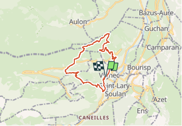
Cap de la Pede 10/05/22

mitch1952
User


6h06
Difficulty : Very difficult

FREE GPS app for hiking
 SityTrail
IGN / Geographical institutes
SityTrail Plus
The world is yours!
About
Trail Walking of 14.1 km to be discovered at Occitania, Hautespyrenees, Vignec. This trail is proposed by mitch1952.
Description
Magnifique journée pour aller au Cap de la Pede et poursuivre jusqu'aux granges du Grascouéou. La montée est assez soutenue, mais le visuel est au rendez-vous. L'Arbizon tout proche est encore pris par la neige. Panorama superbe .Arbizon , Petit Arbizon, Pic d'Aulon,Pic de Portarras, Pichaley,Montarrouyes,Soum de Mattes, Pic d'Arrouye, Pic d'Aret, Pic de Clarabide,Pic de Sarrouyes,Pic d'Espingo etc etc...et on ne peut pas tous les connaître !!! Super journée, et très chaude
Positioning
Comments