


Villanua- Refuge de la Trapa

mitch1952
User
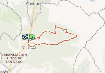

Length
13.7 km

Max alt
1734 m

Uphill gradient
841 m
Km-Effort
25 km

Min alt
952 m

Downhill gradient
840 m
Boucle
Yes
Creation date :
2022-06-06 15:11:25.38
Updated on :
2022-06-06 15:14:05.315
5h39
Difficulty : Very difficult

FREE GPS app for hiking
 SityTrail
IGN / Geographical institutes
SityTrail Plus
The world is yours!
About
Trail Walking of 13.7 km to be discovered at Aragon, Huesca, Villanúa. This trail is proposed by mitch1952.
Description
Randonnée de difficulté moyenne et bien balisée
Positioning
Country:
Spain
Region :
Aragon
Department/Province :
Huesca
Municipality :
Villanúa
Location:
Unknown
Start:(Dec)
Start:(UTM)
702198 ; 4728474 (30T) N.
Comments