


La Brosse

FPortier
User
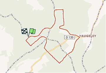

Length
9 km

Max alt
250 m

Uphill gradient
134 m
Km-Effort
10.8 km

Min alt
181 m

Downhill gradient
136 m
Boucle
Yes
Creation date :
2022-06-07 07:21:19.564
Updated on :
2022-06-07 10:13:32.423
2h12
Difficulty : Medium

FREE GPS app for hiking
 SityTrail
IGN / Geographical institutes
SityTrail Plus
The world is yours!
About
Trail Walking of 9 km to be discovered at Grand Est, Aube, Aix-Villemaur-Pâlis. This trail is proposed by FPortier.
Description
Randonnée Bucey 07 06 2022
Photos

Positioning
Country:
France
Region :
Grand Est
Department/Province :
Aube
Municipality :
Aix-Villemaur-Pâlis
Location:
Aix-en-Othe
Start:(Dec)
Start:(UTM)
558037 ; 5341052 (31U) N.
Comments